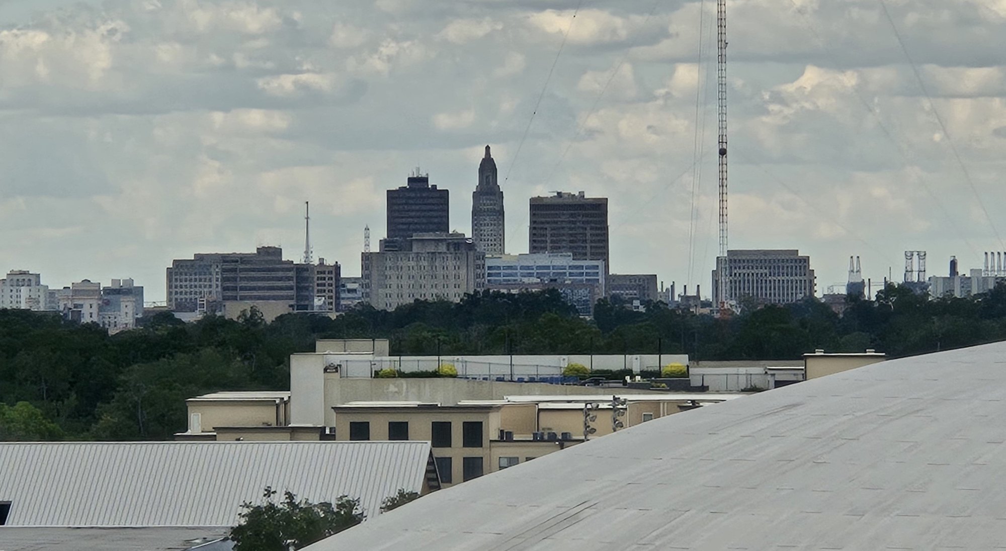
Downtown Baton Rouge viewed from Tiger Stadium

Outdoors

Picnic spots near Baton Rouge

Day-use and picnic areas near Baton Rouge on public land, from quick drives to full-day outings.

8picnic areas
22 mito the closest
1within 30 miles
October–Maybest months

Good to know: Group picnic sites can often be reserved; fire rules change with the season, so check before bringing a grill.

Closest picks

1

Atchafalaya National Heritage Area

22 mi southwest · National Park Service

Our country’s landscape is rich and mysterious. It is filled with twisting bayous, rivers and America’s largest river swamp. We have fields of sugar cane and cotton, ancient live oaks and towering cypress.
2

Atchafalaya Basin

46 mi west · US Army Corps of Engineers

The project encompasses 595,000 acres of the largest contiguous tract of bottomland hardwoods in the United States. The Atchafalaya Basin is a scenic semi-wilderness area of hardwood forests, cypress stands, marshes and bayous.

3

Old River Lock

48 mi northwest · US Army Corps of Engineers

Louisiana's Old River is a distinctive river with a remarkable history. Fifty miles northwest of Baton Rouge, it connects the Atchafalaya and Mississippi Rivers.

Map of all 8 places

Map of 8 places loads as you scroll.

Within 30 miles (1)

22 mi southwest · National Park Service

Atchafalaya National Heritage Area

Our country’s landscape is rich and mysterious. It is filled with twisting bayous, rivers and America’s largest river swamp. We have fields of sugar cane and cotton, ancient live oaks and towering cypress.

  • Biking
  • Boating
  • Camping
  • Fishing
  • Hiking
  • Paddling
  • Picnicking
  • Wildlife viewing

30 to 75 miles (4)

46 mi west · US Army Corps of Engineers

Atchafalaya Basin

The project encompasses 595,000 acres of the largest contiguous tract of bottomland hardwoods in the United States. The Atchafalaya Basin is a scenic semi-wilderness area of hardwood forests, cypress stands, marshes and bayous.

  • Boating
  • Hiking
  • History
  • Nature education
  • Off-highway vehicles
  • Picnicking
  • Water sports
  • Wildlife viewing

48 mi northwest · US Army Corps of Engineers

Old River Lock

Louisiana's Old River is a distinctive river with a remarkable history. Fifty miles northwest of Baton Rouge, it connects the Atchafalaya and Mississippi Rivers.

  • Boating
  • Hiking
  • Nature education
  • Off-highway vehicles
  • Picnicking
  • Water sports
  • Wildlife viewing

55 mi southeast · US Army Corps of Engineers

Bonnet Carre Spillway

Over the years, the Bonnet Carre Spillway has developed into an extensively used outdoor recreation area with approximately 250,000 visitors enjoying the spillway each year.

  • Biking
  • Boating
  • Fishing
  • Hiking
  • Nature education
  • Off-highway vehicles
  • Picnicking
  • Water sports

69 mi north · USDA Forest Service · Campground

Clear Springs Recreation Area (MS)

This location is available on a first-come, first-served basis only. Visitors are required to physically arrive at the campground to purchase and claim a site.

  • Amphitheater
  • Biking
  • Camping
  • Canoeing
  • Fishing
  • Hiking
  • Kayaking
  • Mountain Biking

75 miles and farther (3)

82 mi northwest · US Army Corps of Engineers

Ouachita-Black River - Jonesville Pool

Ouachita-Black Rivers System in AR and LA has four locks and dams. There are boat ramps and picnicking facilities on the river. The Felsenthal National Wildlife Refuge is located along the river near the AR and LA border.

  • Boating
  • Picnicking
  • Water sports
  • Wildlife viewing

112 mi northwest · USDA Forest Service

Kisatchie National Forest

  • Biking
  • Boating
  • Camping
  • Fishing
  • Hiking
  • Horse Camping
  • Horseback riding
  • Hunting

114 mi northwest · US Army Corps of Engineers

Red River Waterway

Red River Waterway, LA, now known as the J. Bennett Johnston Waterway, contains five locks and dams on the Red River. The project is operated by the Corps of Engineers and the Red River Waterway Commission.

  • Boating
  • Hiking
  • Nature education
  • Picnicking
  • Water sports
  • Wildlife viewing

Distances are straight-line miles from downtown Baton Rouge. Listings come from Recreation.gov’s federal recreation database; check each official page for hours, fees, fire restrictions and closures before you go.

Get outside around Baton Rouge

Top 10 Best Tourist Places to Visit in Baton Rouge, Louisiana | USA - English video thumbnail

THINGS TO DO · YOUTUBE SHORT

Top 10 Best Tourist Places to Visit in Baton Rouge, Louisiana | USA - English

A local activity Short shared by Wiki Peaks - Shorts.

Watch on YouTube ↗

Around Baton Rouge

Baton Rouge April 2024 - Louisiana Art & Science Museum
Baton Rouge April 2024 - Louisiana Art & Science Museumxiquinhosilva · CC BY 4.0
Downtown Baton Rouge, Louisiana, 10 Feb 2022
Downtown Baton Rouge, Louisiana, 10 Feb 2022 - 04theMinsk · Public domain
Jay's Bar-B-Q sign, Baton Rouge LA Oct 2024
Jay's Bar-B-Q sign, Baton Rouge LA Oct 2024Paul Lowry · CC BY 2.0

More outdoors near Baton Rouge

Questions

Where is the closest place for picnic spots near Baton Rouge?

Atchafalaya National Heritage Area (National Park Service), about 22 miles southwest of Baton Rouge as the crow flies. Next are Atchafalaya Basin (46 mi) and Old River Lock (48 mi).

When is the best time for picnic spots near Baton Rouge?

Based on Baton Rouge’s average highs, October–May. Conditions at higher elevations can be much cooler.

Who manages these places?

Federal agencies including US Army Corps of Engineers, USDA Forest Service, National Park Service. Each listing links to its official page for hours, fees, closures and current conditions.

Baton Rouge AI

Your Baton Rouge local guide
Hey there!

I'm Baton Rouge AI. Ask about neighborhood food, independent shops, local history or planning a visit.

AI recommendations may be inaccurate. Verify hours and prices. Questions are processed by Cloudflare. Privacy